Where is Mallorca (Majorca) on the Map?
Mallorca (or Majorca) is Spain’s sunniest Balearic Island—but where exactly is Mallorca on the map? How far is it from mainland Spain, especially popular cities like Barcelona? And how does Mallorca’s strategic Mediterranean location make it ideal for beach-hopping, island exploration, and scenic mountain hikes?
ClickMallorca is a local company based in Mallorca with over 10 years of expertise, specializing in excursions, guided tours, and unique activities across the island. Every year, we help thousands of travelers navigate Mallorca’s beaches, villages, and hidden gems. In this easy-to-follow travel guide, we’ll share exactly where Mallorca is, along with essential tips to help you get the most out of its perfect location.
Quick Answer: Where is Mallorca on the Map?
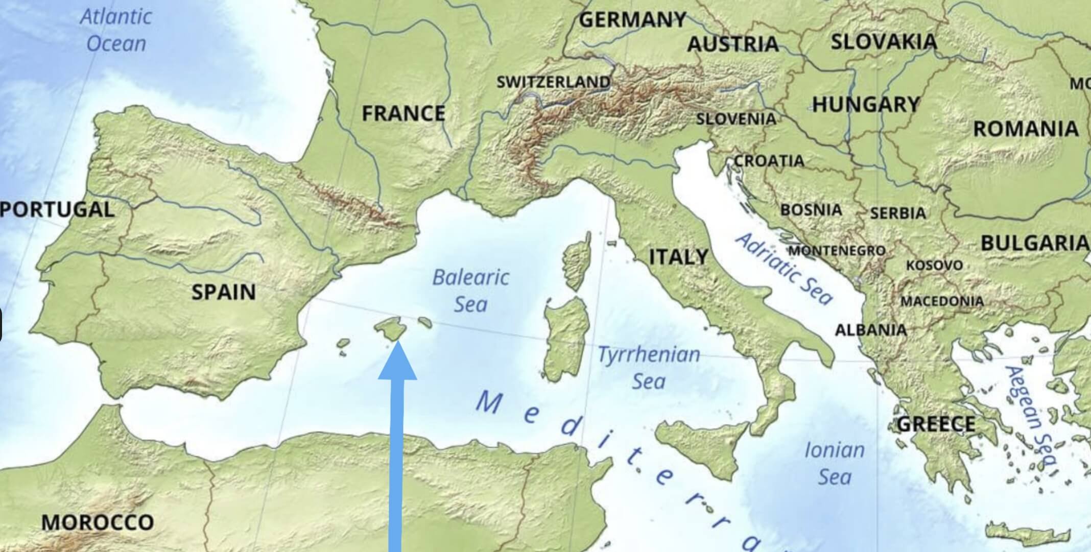
Mallorca is located in the western Mediterranean Sea, positioned at coordinates 39.6953° N, 3.0176° E. Its ideal location—close to mainland Spain, France, and North Africa—makes Mallorca one of Europe’s most popular holiday destinations, offering short travel distances, excellent climate year-round, and countless things to do.
- Coordinates: 39.6953° N, 3.0176° E
- Distance from Mainland Spain: 170 km (105 miles) east of Barcelona
- Closest Major Destinations:
- 🇪🇸 Barcelona, Spain: 45-minute flight (or ~7-hour ferry)
- 🇫🇷 France: 316 km (196 miles) north
- 🇩🇿 Algeria: 288 km (179 miles) south
Thanks to its convenient Mediterranean location, travelers from across Europe choose Mallorca for holidays filled with beautiful beaches, pleasant weather, and diverse outdoor experiences.
Mallorca’s Location: Key Facts for Travelers
Wondering where is Mallorca exactly?
Also known as Majorca, this beautiful island is located in the western Mediterranean Sea, forming part of Spain’s Balearic Islands. If you’re looking for Majorca on the map, you’ll find it just off the eastern coast of mainland Spain, conveniently positioned in southern Europe between Barcelona, Valencia, and the islands of Ibiza and Menorca. Due to its perfect location, travelers frequently ask, “where is Majorca in Europe?” or “where is the island of Mallorca?” Because many people don’t actually realise that Mallorca is part of Spain. Mallorca’s central position makes it one of Europe’s top holiday destinations, with quick connections from major European cities, ideal weather, and countless activities to enjoy.
Here are essential facts about Mallorca’s geography, proximity to major European cities, and nearby airports to help you plan your travels.
1. Geographic Context
- Balearic Archipelago: Mallorca is the largest island in Spain’s Balearic Islands, located in the Mediterranean Sea.
- Area: 3,640 km² (1,405 sq miles)—roughly the size of Cornwall in the UK. More about this on: How Big is Mallorca?.
- Coastline: 550 km of beaches, cliffs, and scenic coves.
2. Proximity to Major Cities
| City | Distance | Travel Time |
|---|---|---|
| Barcelona | 214 km | 1 hr flight / 7 hr ferry |
| Valencia | 260 km | 1 hr flight / 8 hr ferry |
| Madrid | 550 km | 1 hr 20 min flight |
| Paris | 1,030 km | 2 hr flight |
| London | 1,400 km | 2 hr 30 min flight |
2. Nearest Airports
- Palma de Mallorca Airport (PMI): Main international airport, located 8 km east of Palma city center.
- Ibiza Airport (IBZ): 140 km southwest (approx. 45-min flight).
- Barcelona Airport (BCN): Closest major mainland airport, 45-min flight away.
Mallorca’s convenient location offers travelers short flights from major European hubs, making it an attractive destination for both short breaks and extended holidays.
How to Find Mallorca on a Map
Looking for Majorca on the map? Follow this quick, easy step-by-step guide to pinpoint exactly where Mallorca is in Europe and discover its key geographic landmarks.
Step-by-Step Guide
- Open Google Maps (or your preferred map app).
- In the search bar, type “Balearic Islands, Spain.”
- Zoom into the largest island located east of Valencia and south of Barcelona—this is Mallorca.
- Identify these key Mallorca landmarks on the map:
- 🏔️ Serra de Tramuntana (northwest mountain range).
- 🏖️ Bay of Palma (south coast).
- 🏰 Capdepera Peninsula (far eastern tip).
Fun Fact: Although Mallorca belongs to Spain, it’s geographically closer to Algeria in North Africa (288 km away) than to Madrid (550 km away)!
What’s Next? Discover Mallorca’s Best Activities and Excursions!
We hope this guide helped you answer the question, “where is Mallorca?” and understand why its ideal Mediterranean location makes it such a popular holiday destination. Now that you know exactly where the island of Mallorca is on the map, it’s time to start planning how you’ll explore it!
At ClickMallorca, we’re a local company based on the island with over 10 years of experience, specializing in carefully selected excursions, tours, and authentic activities. We focus on smaller groups, local insights, and excellent value—so you can enjoy Mallorca like a true insider.
From scenic boat tours and hidden beaches to mountain hikes and cultural discoveries, we offer something special for every traveler. Browse our top excursions below and start planning your dream Mallorca adventure today! ⬇️🌊

🌴 Things to Do in Mallorca
The best excursions, tours, and boat trips to enhance your holiday experience.
🌟 Why book with us?
✅ Local expertise – We know Mallorca better than anyone!
✅ Smaller groups & top-rated local guides
✅ Lower prices compared to large tour operators
✅ Easy, safe, and secure online booking